
GridScout Map™
This is the console-based Google Maps search tool that you didn’t know you needed. It’ll help you make better use of your paper maps. Without it, the process of finding and marking places of interest is tedious. Let GridScout Map™ solve that so you can get on with your duty of planning for the impending apocalypse, or whatever it is that you do.
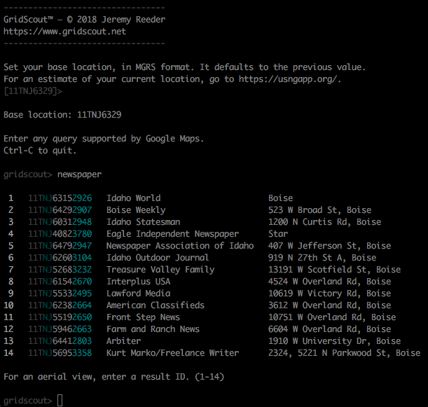
As you can see, it’s a tool for bulk collection of location data, including MGRS coordinates, to be used by intelligence analysts. Finally, MGRS search for Google Maps!
Suggested workflow
- Order waterproof paper maps of your areas of interest. Have them printed with an MGRS (aka USNG) or UTM grid.
- Get some clear plastic overlays.
- Search for points of interest: “power plant”, “tank farm”, “distribution center”, etc.
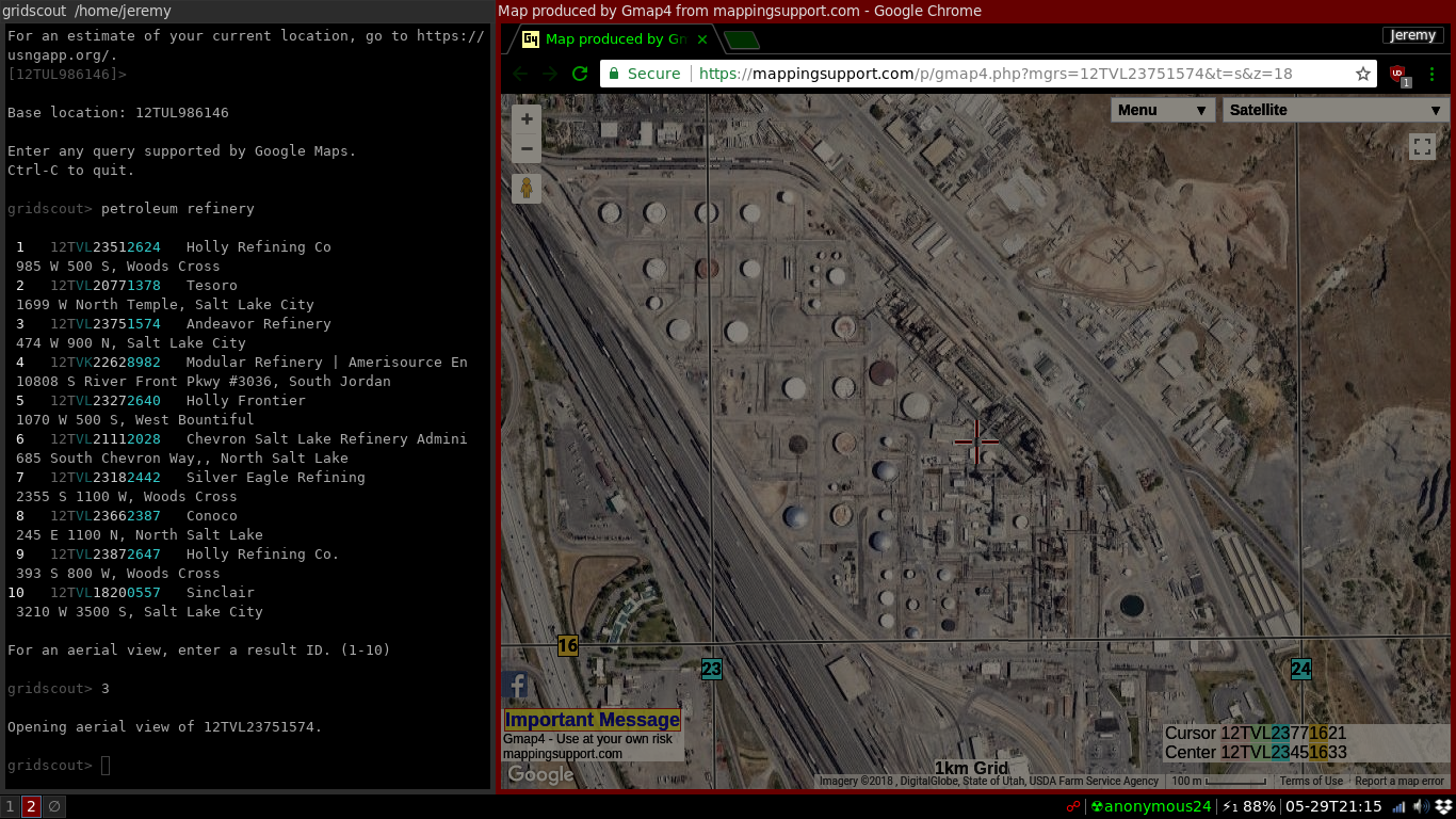
- Select individual results to see aerial and street-level views as needed.
- Edit the GridScout Map™ search log (log/gridscout.log), removing any irrelevant search results.
- Using either the search log or the console output as a reference, plot points on the overlays.
- File the search log away for future reference.
What, no GUI?
For its primary purpose of bulk collection of MGRS coordinates, simple text output in a terminal works well. But GridScout Map™ does integrate with GISsurfer to give aerial views in your web browser. From there, you can easily access other online resources such as topographic and street-map views. Strictly speaking, however, these are not part of GridScout Map™.
Seriously, paper maps?
Going into battle dependent on vulnerable infrastructure is unwise. So yes, actual printed maps and overlays are advantageous. They work independently of power and communication grids. They’re durable, highly portable, and low-maintenance. Fancy technology has its place, but printed maps excel in the field. With GridScout Map™, you can apply the technology without the vulnerabilities. That is, it puts your computer and the Internet to good use now, and it helps you record on more durable media the information that you’ll need later.
Why MGRS coordinates?
The Military Grid Reference System is a whole-world variant of the UTM coordinate system. It’s used by NATO militaries because it’s concise, minimizes distortion, and makes for easy math. Latitude and longitude are greatly lacking in these qualities. Map vendors such as MyTopo allow you to have your maps printed with a UTM grid, and for the aforementioned reasons I suggest that you take them up on that option.
How do I get GridScout Map™?
It’s on GitHub, where you’ll find installation instructions. And it’s free!
Are my searches secure?
Searches go through Google. They are encrypted so that only you and Google can read them. They’re associated with whatever Google account you choose to use when you create a Google Places API key. No, you can’t trust Google. If a better service can be found elsewhere, then we may ditch Google in the future. In the meantime, if you require complete anonymity, then create a Google account that is not associated in any way with your actual identity. Then use it only in public places like libraries and coffee shops, and only while wearing a mask; or use an anonymous VPN service such as ProtonVPN or Tor, which will conceal your location with less trouble. Lastly, when setting your base location, don’t use your exact actual location unless you’re okay with Google knowing it. Truncate your coordinates to 10-kilometer precision if you like, or set a base location on the other side of town; your search results won’t be drastically affected.
Aerial views are accessed through GISsurfer. When you access the aerial view of a location, your web browser will submit that location’s MGRS coordinate in an encrypted manner. Depending on your network and the configuration of your browser, it may be possible for GISsurfer to determine your actual location regardless of the base location that you used for your searches. If this is a serious problem for you, then don’t use the aerial view.
Blog
Subscribe to the GridScout™ blog to keep up on our manly pursuits.
Legal notice
Site icon, made by Freepik from flaticon.com, is licensed under Creative Commons BY 3.0.